Sevilla and Masdar City. When the past and the future meet in the present.
Dear Anthony,
You know I´ve always been a summer person, I love the heat and the light that comes along with this time of the year.
Ever since I was a little girl and I used to play with friends in the streets, I learned how to take advantage of the way my city, Sevilla, was designed. Somehow it was the perfect playground with its narrow streets where the sun rarely reached us directly. I learned the reasons why way after these memories took place.
Many civilizations have passed through this land, and each of them have left pieces of wisdom impregnated in our walls. House of Muslims, Christians and Jewish -all at the same time at some point in history- pictures Sevilla as an example of integration where all the knowledge of different civilizations get together to create a unique city adapted to the idiosyncrasy of its climate and its inhabitants.
Thousands of years after Sevilla appeared in the maps, the City of Masdar was born. Concretely was in 2006 when the project was started by the British architectural firm Foster & Partners. Before the project took off, the team of urban planners went to the eldest cities on earth, like Cairo, Muscat and even Sevilla, to learn more about its ancient urban structure and the way they were designed to mitigate the high temperatures.

Thanks to the master you know I´m currently studying, I find really inspiring how words such as sustainability or responsibility are occupying any headline that stands out nowadays, but the more I learn, the more I think we´re just looking backwards, back to the basics when we used to observe Mother Nature and create in consequence taking advantage of what she provides us.
Throughout the chat I had with the –also Andalucian- architect Gabriel Verd, I was surprised, rather amazed, with what for me was a complete new concept but a knowledge that have been used for centuries and now is back trending. I´m talking about bioclimatic architecture.
What characterizes this architectural style is the symbiosis with nature, relying on the characteristics of the site (climate, vegetation, topography and geology of the soil) in order to be more efficient.
This efficiency can be seen, for instance, in the use of energies, which are minimized due to the adaptation to nature´s features.
For me it has been really appealing to learn about bioclimatic architecture. I´m able now to explain many traditions of my culture that I would love to share with you:
- Our streets are narrow and windy, able to mentally transport you to the souk of the prettiest city of Far East. The reason why is due to the high temperatures we have during spring and summer, easily reaching 45 degrees Celsius. This way the sun would rarely reach directly pedestrians, which helps to keep up with the normal rhythms of life.
- Many of our houses are covered in clay, this material captures the heat during the day and releases it along the night.
- Also something very characteristic from my culture is to paint houses in white, as you can find throughout all Andalucía, there are many towns which houses are all painted in this color because it doesn’t absorb much heat.
- An essential and central element of our culture are the patios. These spaces are designed as mattress elements to refresh the house, since every patio that boasts has its fountain to humidify the environment and, of course, always keep in mind that constant noise that characterizes us, the flow of water.
- Plants are also very important for us, they not only clean the air through the absorption of CO2, but also protect the buildings from the high temperatures. Climbing plants are very typical and something that would never go out of style.
- Light is a must in our spaces, natural source of vitamin E and let me dare to say that one of the sources of our happiness. That’s why we love the windows, the bigger, the better. During the winter, this creates a greenhouse effect, which we use as natural and free heating, reducing dependence on other energy sources.

When you come to Seville I would love to show you what is, without any doubt, my favorite place: the Alcázar. Example of bioclimatic building and symbol of our roots. The combination of its latticework, its patios, its vegetation and its south-facing galleries make this 10th-century monument a landmark building today.
The Arab blood runs through our veins, it is a fact and that’s why I like to compare ourselves with our cousins from Middle and Far East, although with a leap of several centuries.
Concretely, I have to recognize that I’m completely fascinated by the City of Masdar. Part of this city already exists and the plan is to finish it by 2030, although this date has been delayed ever since the project started back in 2006.
The original master plan envisioned a city functioning on its own grid with full carbon neutrality, designed using the same paradigm of bioclimatic architecture which will host 50,000 people and 1,500 business at the outskirts of Abu Dhabi.
It was back in 2016 when they ratified that the plan of the net-zero carbon level would never be reached, due to the complexity of the figure and because we also need to take into consideration the geographic characteristics of the city, located in the middle of a dessert.
Even though they will never be able to reach the levels initially projected, the city will be fully supplied by renewable energies. Concretely, Masdar is powered by the solar plant called Shams. The Shams-1 plant generates 100 MW of solar power and covers approximately 741 acres of desert. It has a solar field of nearly 6,458,346 square feet, with 768 Abengoa Solar parabolic troughs.
Here I need to allude, once more, to the connection we both have. The project is being developed through a joint venture made up of Masdar (the subsidiary of Mudabala Development Company which is building the City of Masdar), Total and Abengoa Solar, the multinational company with headquarters in Palmas Altas, Sevilla, a brand new intelligent building.
As not all that glitters is gold, they are having some issues with their PV (photovoltaic) and CSP (Concentrated Solar Power) panels, due to sand storms:“Blowing sand has been a problem for its solar panels, so Masdar has been working with other companies to engineer surfaces with pores smaller than sand particles to stop them from sticking on the panels. Scientists at the Masdar Institute are also working on coatings that repel sand and bacteria for use on solar panels and in other applications.” The technology they are developing will be used in other places with the same problems, so they can really take advantage of the power of the sun in deserted areas.
Because this urban area is efficiency-oriented, in the City of Masdar we won´t be able to find light switches or water taps; movement sensors control lighting and water to cut electricity and water consumption by 51 and 55 percent respectively.
Another renewable measure they plan is to manage water “in an environmentally sound manner and reuse it as many times as possible”. From a personal point of view, I believe this statement is pretty vague and it´s basically all the information they have regarding water management in a city located in the middle of a dessert. I guess they still have time until 2030 to find the way to manage it better.

Dear Anthony, you know I love talking so let me please summarize the key ideas I wanted to talk you about in this letter:
- Sevilla is a wonderful city, please don´t miss the chance to come and visit.
- We love the heat, is part of our history and throughout the centuries we have learned how to take advantage and use nature to mitigate the effects of the high temperatures.
- You´ll be able to see it when your own eyes when you come to have a walk through the city center, where streets are narrow and windy, our houses are white and our patios humid.
- But the man does not only live out of bread, we have great businesses in our city, Abengoa for instance, with its intelligent building Palmas Altas, which has projects all over the world, concretely they have built in partnership with Total and Masdar, the largest solar plant in Middle East.
- With this plant, called Shams, in Arab United Emirates they will supply the City of Masdar, the city of the future that combines bioclimatic architecture with high tech to be the most efficient city on earth.
- Because the project of Masdar is really ambitious, they are having some issues regarding the renewable energy resources they planned at the beginning, but they are sorting the problem out little by little.
So remember, any time you feel like having a break, Sevilla will be there waiting to host you!
Love,
Cristina.
Biography:
- Interview Gabriel Verd
- Alcázares de Sevilla. History. http://www.alcazarsevilla.org/historia/
- Masdar city. Technical information https://en.wikipedia.org/wiki/Masdar_City#Renewable_resources
- Bioclimatic buidings http://www.concept-bio.eu/bioclimatic-architecture-buildings.php
- Abengoa Solar. Shams-1 http://www.abengoasolar.com/web/en/plantas_solares/plantas_propias/emiratos_arabes_unidos/index.html
- Interview Jaime López de Asiaín. Bioclimatic Architecture. http://www.paralelo36andalucia.com/la-arquitectura-bioclimatica-entrevista-a-jaime-lopez-de-asiain/
Enviar comentario /
27 Jan 2017
por
Cristina Kirkendall
 IMSD /
More parking meters in Mexico City = Less cars
If I could describe Mexico´s public and private transport in one word I would say: chaotic. According to Forbes magazine Mexico City is the #1 city with more traffic in the world, spending more than 59% extra time in the car. But what are we doing wrong?
The Institute of National Statistics and Geography (INEGI) indicates that 25% of the population is concentrated in Mexico City; this means that around 30,000,000 people are trying to move from one place to another practically every day. Of all these trips, between 70% and 80% are made in public transport.
The origin of this problem is that the majority of the public investment is focused in vehicular infrastructure for new roads, parking lots, overpasses, road distributors, among others. This way the government is promoting the use of cars, creating more traffic. This type of development focus in automobiles is inequitable and excludes a lot of people because only 30% of the population owns a car.
More car trips = more vehicular congestion = higher energy consumption = more pollution
The excessive use of cars has a negative cost for the whole population, we have economic losses due to the congestion, health problems, accidents and environmental damage to name a few. Regarding pollution, 34 million people are been exposed to poor air quality (INEGI) . This is having an impact in people, sometimes even death. In 2016 we reached the highest level of pollution in the air according to IMECA (Metropolitan Air Quality Index in Spanish), so the government decided that during 3 months every car could not circulate once a week and once a month on weekends to reduce the air pollution.
But it is not all bad news. Fortunately The Institute for Transportation and Development Policy (ITDP) has been working in Mexico since 2006 promoting sustainable and equitable transport, with the aim of improving the life of the citizens, where people are put before cars.
They work to have cities with less congestion, less pollution, fewer accidents and healthier, safer, more productive communities. To be able to achieve this they follow 8 principles:
- WALK | Develop neighborhoods that promote walking
- CYCLE | Prioritize non-motorized transport networks
- CONNECT | Create dense networks of streets and paths
- TRANSIT | Locate development near high-quality public transport
- MIX | Plan for mixed use
- DENSIFY | Optimize density and transit capacity
- COMPACT | Create regions with short commutes
- SHIFT | Increase mobility by regulating parking and road use
ITDP has made several projects in Mexico City. They started in February 2010 with the first public bicycle program “Ecobici” with 1,114 bicycles and 85 stations, they also support the rapid bus “Metrobus” and collaborated with the parking meters.
ITDP is working in solutions focused in mobility. They strongly believe that the solution for traffic is not the construction of new roads and parking lots, since with time this creates more traffic because it promotes the use of the car. This organization proposes that the correct use of parking lots in and out of the streets can help solve this problem. This means that the space in the street should be administrated. If we think about it, cars spend most of the time stopped and we are not addressing this properly. Due to the lack of public parking people park in secondary and tertiary roads, in sidewalks, gardens, alleys, boulevards and cycle paths.
Parking is free, so the streets are full of cars and the drivers do not have any other alternative than leaving their cars in any space that is available. It has become very problematic to find a space to park the cars and as a result a new “job” was created: franeleros o viene vienes. These are people that appropriate the free parking spaces and charge you to park in the street. The franeleros are supposed to keep an eye on the car and they get a tip for this. In 2007 it became illegal due to their relation to organized crime and illegal use of public space.
As a result of what I mention before, in 2012 the first parking meters were installed in Polanco, an affluent city neighborhood. This devices have the objective to regulate, by charging money for a limited time the use of spaces for parking vehicles, this includes administration, monitoring, supervising and fines. Using them has several benefits: reduces the use of cars, reduces traffic, decrease in emissions, improvement of road safety and public space, easy and fast develop, increasing availability of parking, among others.
This promotes the constant rotation in the occupation of the parking space and facilitates the mobility of people and goods in areas with high activity.
The benefits of the parking meters can be seen immediately. First the parking space will be used more efficiently and therefore more free spaces will be available, second the circulation improves and people saves gasoline because they don’t need to spend too much time searching for a parking space, and third the economy is more efficient because the drivers will find a parking space quickly buy something and leave, this allows other consumers to use the parking space.
 According to ITDP the parking meters helps to reduce 30% the use of automobiles
As I just mentioned, Polanco was the first district in Mexico City where the parking meters were installed. This area is well known for its cultural diversity and home of some of the wealthiest families. It is also popular for having museums, restaurants, offices and street Avenida Presidente Masaryk with the most upscale boutiques (the Mexican version of New York’s Fifth Avenue).
This neighborhood was chosen because it used to have a parking problem and as a result the greenhouse gas emissions were increasing. The government of the city and the Secretary of Urban Develop designated this area. The Institute for Transportation and Development Policy with the support of the British Embassy made a previous study and created an implementation plan with policies and periodical revision to monitor if the parking meters are fulfilling their objectives.
In this detailed study the ITDP found out some interesting facts that helped the implementation. For example: almost half of the transport used in Polanco are private cars, 68% of the people that goes to this area is because they work there, 85% of the people that live in Polanco own a car, the total amount of kilometers traveled daily inside this neighborhood are 159,613, the volume of cars parked at different hours, the speed in different areas, how many parking spaces were available, and that it took people 14 minutes to find a parking space, among others.
The parking meters in Polanco are considered a successful project but at the beginning it was a social challenge. There were several myths, for example: that the government keeps the money of the parking meters, that paying to park in public space harms the shopping areas, that there are not enough parking spaces in Polanco and that we should create more, among others.
And as expected, the franeleros were against this project because it would leave them without a job. Several marches occurred in Polanco and even the first day they “closed” all the parking meters as a sign of discomfort. Even though the parking meters are working, every time they expand people get really mad, this pattern has been repeated several times in other districts such as Coyoacán, Anzures, Tlalpan, la Condesa and more.
Personally, I do feel a huge change in Polanco. Before, it was impossible to find a parking space and eventually I would leave my car with a viene viene that charged me an unfair price. The neighbors are pleased because they can find parking space in 1 minute and the area has become safer. Regarding the money that is collected by the parking meters, 30% of the funds are used to recover public spaces and the neighborhood committee can decide where else to invest. The first year 2,590,909 euros were collected and 30% was used to recover sidewalks, in the past 5 years there has been a remarkable change in this area.

I had the chance to talk with Xavier Treviño from ITDP who participated in the implementation of the parking meters. After the first year he made the initial assessment of the impacts of this program in Polanco. I took this opportunity to learn about the project from the inside and ask about the acceptance and rejection of the parking meters in Mexico.
Xavier explained to me how the idea was born. In 1994 two neighborhoods were chosen (Juarez and Cuauhtémoc) to have parking meters. The problem was that the operator was 100% private and that the parking meters were badly managed, so it was impossible to replicate this same system in other parts of Mexico.
ITDP, with the support of other NGOs and experts started to collaborate with the Secretary of Housing and Urban Development of Mexico City. At the beginning Polanco and La Condesa were considered to launch the project, but the final decision was to only start with Polanco.
Polanco was chosen because most of the buildings have parking lots for the residents so most of the parking spaces in the street were occupied during the day by people that were working or shopping in the area. For this first project the Government didn’t make a poll with the community, they just implement the parking meters.
Another interesting topic that I discuss with Xavier was the price. He explained that one of the main reasons people are against the parking meters is because they don’t trust the way the government uses the funds. As I mention before 30% is designated to the neighborhood and the other 70% is for a private company that operates the parking meters. Xavier pointed out that these private companies are contracted to give a service (the same layout that they use for the telephone booths). Also there is not an exact reason why this percentage was assigned, but is supposed to cover all the expenses the private company has plus their earnings.
After the project in Polanco was launched, 12 more projects were implemented in different neighborhoods of Mexico City, but since 2014 the government decided to stop. Xavier explained me that Polanco was an outstanding project that worked very well in that specific zone. This same scheme was implemented in all the neighborhoods, but the problem was that it worked in some places but in others failed. This happened because Polanco`s buildings and houses were constructed to store a lot of cars but in other neighborhoods like Colonia Nápoles the houses were constructed without parking spaces. The problem is that the government implemented the exact same rules in all the parking meters with no flexibility, and this is not working. This is why since 2014 the project stopped.
Talking to Xavier was very useful because his experience helped me see things form another perspective and provide insight that internet cannot provide.
After this research, I see a positive panorama for Mexico, we have a lot of work to do, but it can be done. I think the parking meters still have area for improvement. For example they devises should be able to accept bills and credit cards, the schedules should be adapted to each area, government should have more awareness campaigns explaining the neighbors the benefits they will have, annual reports with the positive impacts of each area and how the money was invested, among others.
The parking meters was just an example of a project that started in 2012, but a lot of things have been done since. For starters now we have bicycles and a bus with its own lanes.
I believe that if the government turns around and instead of investing 70% of the budget in private transport, uses it in public transport, we would see a significant change. We need to change the way we see the cities and the way we move.
Sources
- Políticas públicas destinadas a reducir el uso del automóvil, Implementación de sistemas de parquímetros para ciudades mexicanas, ITDP, (2012) Available at: http://mexico.itdp.org/wp-content/uploads/parquimetrosOK.pdf
- Menos cajones, más ciudad. Estacionamiento en la ciudad de México, (2014), Available at: http://mexico.itdp.org/wp-content/uploads/Menos-cajones-m%C3%A1s-ciudad.pdf
- “Implementación de parquímetros en Planco, Estudio de línea base”, Instituto de Política para el Transporte y el Desarrollo (2013) Available at: http://mexico.itdp.org/wp-content/uploads/implementacion-de-parquimetros-mayo2013.pdf
- “Guía práctica Estacionamiento y Políticas de Reducción de congestión en América Latina” Banco Interamericano de Desarrollo (2013)
- CDMX Ciudad de México, Ecoparq. (2017) Available at: http://www.ecoparq.cdmx.gob.mx/index.php/ingresos
- Jim Gorzelany, Forbes magazine, (03/27/2016) Available at: http://www.forbes.com/sites/jimgorzelany/2016/03/28/the-worlds-most-traffic-congested-cities-2/#34b2f5065f06
- Instituto Nacional de Estadística y Geografía, INEGI, Available at:
- El Financiero, Salvador García, “El transporte público un insulto al pasajero”, 04/19/2016, Available at: http://www.elfinanciero.com.mx/opinion/el-transporte-publico-un-insulto-al-pasajero.html
- La Jornada, Laura Gómez, “Rechazo y descontrol en el primer día de la operación de parquímetros en Polanco” (2012) Available at: http://www.jornada.unam.mx/2012/01/10/capital/032n1cap
Enviar comentario /
27 Jan 2017
por
aespana
IMSD /
PARQUES DEL RIO, THE BEST SOLUTION?
Context
Medellín, once known as the most dangerous city, was internationally awarded as the most innovative city in the world in 2016 as a recognition to the transformation the city has had in the last 20 years. Now it has become a leading city in Latin America and is one of the most visited places in Colombia. But also, was the winner of this award due to to the innovative solutions as a response to the urban challenge that growing population represents. However there is a question that remains, is Medellín really looking all the options and adapting the ones that really are going to make a change in the sustainable growth of the city or it is moving according to political interests?
Medellín is the second most important city in Colombia after Bogotá, and is the capital of Antioquia (full of opportunities, high standard education, job opportunities among others) which makes it yearly receptor of people coming from smaller towns and other cities. But it is also important to mention that as a result of the expansion of the city, the borderlines with near municipalities got lost. This is why in 1980 Medellín and 10 other municipalities became ¨Area Metroplitina¨ (MA) which the main purpose is to promote a dynamic integration which leads to a sustainable growth of the region.
Since the settlements of the first inhabitants in Medellín and in the Metropolitan Area, there has always been a ¨geographical¨ issue that has shaped the culture and development of the cities. This became the main causes of the challenges that the MA is facing today: it is located in a valley divided by the Medellin River. In the past, people had challenges as transportation and commercial difficulties that finally overcame and from there ¨paisas¨ (how people from the region is called) are known as vigorous people, but as the cities grew the challenges grew as well and new ones appeared: expansion of the city to the hillsides, mobility limitations and raising pollutions levels.
In order to face these challenges, the land management plan prioritized three main areas: Land, hillsides and the recovery of river vitality. These main aspects should be the guideline to design, decided and execute projects in all the municipalities of the Metropolitan Area. Therefore, projects as the metrocable, the tram, and the new water treatment plant and the most recent one: Parques del Río, are being built.
Parques del Rio
Parques del Río was signed in October of 2013 as a response to the challenges of the city and guided by the projection made by the Metroplitan Area and experts for the region by 2030 in public document called BIO2030. In this projection, the river will be the axis of development of the city in social, economic and environmental ways and will integrate Medellín, Bello, Sabaneta, Envigado, La Estrella, Caldas, Itagüí, Barbosa, Girardota y Copacabana
It was estimated to be a long run intervention (approximately 10 years) divided in eight sectors and each public administration will be in charge of building a certain part of it.
In order to guarantee the transparent management of the project, a legal society/company was created called MEI. It is integrated by Empresas Públicas de Medellín (EPM-public service company) , Interconexión Eléctrica S. A. (ISA) and a company Sistemas de Infraestructura Lineal. Their responsibilities will be to look after the operation, financing, collection, and final approval of the works.

3 main objectives of the project:
Mobility: Nowadays the highways (south and north) built next to the river are the most important roads of the Metropolitan Area. Since they go through all the municipalities, it becomes the daily route of those who lives in other cities and come to work to Medellín and vice versa. But also they are the main access point to Metropolitan Area for trucks and cars coming from outside the MA, highlighting its relevance for the transportation of products and merchandises and also essential for the local industries to export their productions nationally and internationally.
The alarming situation is that these highways will have to face not only the growth of population in the MA which will put pressure to the system by adding more cars to the road. But also it is expected that with the national project named ¨Autopistas de la Prosperidad¨ the amount of current traffic (mainly trucks) will double in the next years. So in the next 25 years, the north and south highway of the MA will have to respond to the demand of 3,9 million vehicles that will have to cross them in order to communicate with the rest of the country.
According to the projections of the raise in the amount of vehicles using the highway, Parques del Río will add 126 km-lane (today is has 185km-lane and it will come up to 311 km-lane) of which the 36% of it will be underground, leaving public space for social or mobility alternatives like bicycles (32 km of bike lanes) and pedestrian paths (34 km)
Environment: During the last 20 years, Medellín has invested approximately 1,5 billion dollars in the improvement of the quality of the water of the river paid with the local taxes and water bills. This is why, through this project, the city wants to give back to the citizens the possibility to enjoy again the river and places around it.
The Metropolitan Area, now counts with two water treatment plants in order to guarantee the quality of the water, but also the project expects that by facilitating the contact between the people and the river, the habitants of the cities will be more aware of their impact in this resource since not only the industry pollutes the river but also the neighborhoods that are settle next to a affluent that ends up in el Río Medellín
Public Space: While the Metropolitan Area area grows public spaces gain relevance since they become spaces for habitants to interact and recreate. This is why with Parques del Río, 1,6 million m2 have been projected to be destined for public spaces and green areas. In the first stage there will be 322.000 m2 that will be consolidated as the central park of the Metropolitan Area.
These square meters are seen as the opportunity to improve peoples lives of all the MA habitants, specially in the first stage to neighborhoods of Conquistadores and Naranjal and the users of close areas like Plaza Mayor, Metropolitan Theater, and La Alpujarra (Cityhall)
But the project does not only want to offer new public spaces, it also has a major goal by playing a role in the solution to the growing population in the hillsides which has become an important issue due to the lack of planning in the colonization of these areas and the risks this implies for people’s safety. The reality is that for the MA it is estimated that more than 800 thousand people will come in the next 40 years and the raise of the demand for living places will grow 18% between 2010 and 2020 and 6,2% from 2020-2030. Therefore the only two options are to settle in the hillsides or to settle next to the river. This is why with Parques de Rio one of the main purposes is to recover lands that are not being use in the most efficient way (like for example old storages of companies) and use them as places to build, next to the private sector, new residential projects like for example Ciudad del Río

Parques del Rio: the ¨bone of contention¨
So why if the project has this noble purposes and its main goal is to transform the Metroplitan Area in order to offer a better life to the habitants, it has been so polemic and has divided he city in two?
In 2015, the project started during Anibal Gaviria´s. The firs part that was going to be build, was split in two parts: part 1A in the west side of the river that should have ended in 2015 and part 1B that should end in 2017, in the east side. The budget estimated, authorized and paid for both sides was 454.000 million pesos. The money came from the sale of telefonía UNE to international company Millicom.
But problems started to appear as the project was running. Some of the most important ones were/are:
- Due to a cost overrun of the firs section, it will end up costing 577,000 million pesos (near 120,000 million pesos more)
- Infrastructure and building difficulties
- The complains of the citizens due to the mobility difficulties and chaos
- The concern of the habitants of the near neighborhoods for the possibility of insecurity of the park since it could become the ideal place for homeless people
- The judgment for to the public administration for not using the money for something else
- The environmental and visual impact that caused the cutting of trees
- The lack of transparent and appropriate communication of the project to the citizens.
Added to all these doubts, comments, and concerns, the actual administration in head of Federico Gutierrez, has a critical position about the project. According to Luz Marina Lopez the secretary of infrastructure, this administration will build the section 1B which was already signed by the previous administration. But reality is that they have other priorities also to achieve the three main purposes mentioned before, these are: the improvement of 100 public parks, destination of 600,000 million pesos to the new tram in an important street call La 80, new infrastructure in the highway to improve mobility, the new water treatment plant that EMP is building, a new metrocable, improve the mobility in comunas 1,3 and 8 and also they are developing next to the private sector a home building project.
In general, she thinks Parques del Rio is a very well structure and valuable project, but since it demands a big amount of money she considers that each mayor should decide how they are going to build their correspondent section and let them find them the best way to do it, because how it is presented today is very rigid. This became a problem since for example the past administration made some improvements in el Poblado and paid them thru valorization so this new administration, that was thinking to continue the project funded thru this system as well, didn’t see it possible due to previous valorizations charged to the people.
What do the experts have to say?
Carlos Cadena Gaitán: urban planning professional, focused in sustainable urbanism. He is a teacher at Universidad EAFIT, investigator, columnist, activist and coordinator of La Ciudad Verde.
From his point of view, the project shouldn´t be evaluated just for the first section (1A that is already done and 1B that will start during this year), it should be seen as a whole and mainly as a great achievement for the city since it will bring back live to the river, will reunite the society, and will allow people to cross the river in bicycle or waking following the path visualized in BIO2030
Unfortunately for him, the actual administration didn’t establish the project as a priority so they slow down and has delayed the construction of the part 1B and for what has been built it can´t been seen a real change and impact over the three objectives: mobility, environmental and social integration.
Thinking about other alternatives that could have been done or that could be done with the budget invested in this project, he says that he doesn’t see any alternatives that could respond to the main issue which is giving life back to the river.
As well, he questions the priorities that the current administration has because they have been investing, in his opinion, in projects that won´t create a great impact in the city like the improvements in the streets in el Poblado (neighborhood) which cost 400,000 million pesos and benefits and promote the use of cars instead of encouraging the use of public transport. He assures that budget for the other sections could be obtained by private companies, tolls, among other alternatives.
Finally, he strongly believes that a cultural change could be done and that people will be willing to live near the river instead of living in the hillsides, are willing to share with people from different social classes and will turn to public transport and the use of bicycle and like this achieving the log pursued goal: social integration.
Luis Fernando González: Associate professor to the Escuela del Habitat of Univerisdad Nacioal
Even though, projects are designed with the best intentions, they have to consider the political, economical, historical and geographical context of the place where it is going to be executed. This is what happened in the case of Parques del Río in Medellín, a very good idea that has succeed in other parts of the world, but didn’t considered the limitations that the Metroplitan Area has.
Regarding the mobility issues, he thinks the project is not giving a real solution to this increasing problem because, instead of promoting the use of sustainable ways of transportation, they are adding more kilometers and lines to the highway which will bring more cars to the street. Also, the part that is being built (1B) will become a structural problem for the ¨multiproposit train¨ that is conceived in the Mobility Master Plan and solving it will incur in extra expenses.
On the other side, he states that the idea of having a clean river were people can go fishing, swim or actually enjoy, is a not a real scenario due to the actual quality of the water which not even with the new water treatment plant, is going to recover enough properties to be used as a reactional attraction.
About the third purpose of the project, he mentions that it is also questionable the idea that the riversides and the buildings constructed there will contribute to social integration because what these types of project finally do, are rising the price of the land, like in Ciudad del Rio which was finally occupied by high income people. Also the cost that implies for low income people to get to the riverside parks are to high which will be an ¨invisible barrier¨ for them to use Parques del Río.
Finally, he thinks the money should have been invested in the Mobility Master Plan projects like the new tram that this administration wont be able to finish due to lack of budget that was destined to Parques del Rio. Medellín is going thru a very difficult environmental situation as a result of the increase of car use. He questions who is going to decrease the pollution levels, the river or the public transport? The sectors left to built represents a great amount of money and for sector 1 there was money but for the other sectors there is no budget and the other municipalities are not financial participating which lead to another topic of corruption and the mismanagement of economic resources provided by EPM.
 Conclusions
Medellin and the Metropolitan Area in general, due to the topographic conditions is facing a huge challenge as the populations grows and solutions to relevant issues as pollutions levels, population settlement, and integration/green spaces, must be taken as soon as possible. But even though serious studies (BIO2030 or the Master Mobility Plan) have been done where it is clear the course that the city should follow, political interest stand in the way of the development of the cities considering that each mayor want´s to be protagonist so they just decide a ¨personal¨ project and go for it but at the end they are not part of a long run vision.
This could be related to Parques del Río where the initial idea is interesting and has a valuable purpose since it integrates different variables and it is raised as a long term initiative which should engaged all the administrations from now to the future. But apart from this, the benefits that it will carry on are not cost-efficient since the real objectives achieved probably won´t worth the investment. At the end, real mobility projects are in standby waiting to be done. Additionally, it is not a secret that the other cities of the MA don´t have the same financial capacity as Medellín has, so Medellín will be paying for a project that will benefit other cities? And should Medellín use EPM recourses to invest in this?
At the same time, social integration has always been a challenge not only in Medellín but in other parts of the world, and the execution of Parques del Rio unfortunately is not guarantee that this will happen on the contrary it will be a very expensive experiment. It requires changes in people´s perceptions and prejudices and this cultural change should be done in a smaller scale to actually see a change and not ending like Ciudad del Rio were high income people do picnics.
But also for the water pollution a cultural change must be done, and it should start with companies so they improve their production systems in order to prevent the water pollution instead of build more water treatment plants. Even though Parques del Rio claims for the river protection, the big impact and solutions are not in its hands but in regulation and promotion of better practices.
Finally, its important to highlight what Parques del Rio has achieved in terms of thinking in a long term which rarely happens in cities in Colombia, so the call will be to rethink the project, redesign it to it can be done, probably in a smaller scale or by making some changes keeping the most valuable parts of it, but without compromising the budget for other priory projects that will also transform the city.
Bibliography
- Nuestra nueva Medellín, Parques del Río, 2015
- BIO 2030 PLAN DIRECTOR MEDELLÍN, VALLE DE ABURRÁ, Primera edición Diciembre de 2011
- El Tiempo (29/02/2016) ¨Siguen las discusiones por costos de Parques del Río. Retrived 24/02/2017 from:
http://www.eltiempo.com/colombia/medellin/siguen-discusiones-por-costos-de-parques-del-rio/16523846
- El Tiempo (12/04/2015) ¨Así será Parques del Río, el nuevo ícono de Medellín¨ Retrived 22/02/2017 from
http://www.eltiempo.com/colombia/medellin/obras-de-parques-del-rio-en-medellin/15555115
- Revista Semana (12/4/2015) La multimillonaria obra que divide a los paisas
Retrived 22/02/2017 from
http://www.semana.com/nacion/articulo/la-multimillonaria-obra-que-divide-los-paisas/423902-3
- Interview: Luz Marina López, Ex secretary of Infrastructure
- Interview: Carlos Cadena Gaitán, expert in urban planning
- Interview: Luis Fernando González: expert in urban planning.
Enviar comentario /
27 Jan 2017
por
sgonzalezmoreno
IMSD /
Urban Permaculture in an Urbanized world
The first city (that we know of) in human history was the Sumerian city of Uruk, sometime between 4500 and 3200 B.C. Much happened since, the last century saw a rapid urbanization, as the global proportion of urban population rose from 13% (220 million) in 1900, to 29% (732 million) in 1950, to 54% (3.8 billion) in 2014. What options do we have if, according to United Nations statistics, by 2050 over 6 billion people, two thirds of humanity, will be living in towns and cities?
As we all know, cities may have many positive things, but they are major producers of pollution. Therefore, this future prospect could be very bad for both people and the environment. Even in developed countries, where the newest sustainable technologies are applied, contamination seems to arise from every corner. Air pollution causes nearly half a million premature deaths each year in the European Union. In busy cities, air quality is usually at its worst, with high concentrations of particulate matter (PM), nitrogen dioxide (NO2) and ozone (Ref).
But we cannot help it. People like living in cities, even those who often say they hate it and that they are tired of being surrounded by people and noise and concrete. Even they like having their friends close, they like having a higher salary, they like having many places to choose when they want to eat, or being able to run into a cab when rain catches them by surprise. Even they are still living in the city. That is because cities provide higher living standards than rural areas (this includes political activism, education, infrastructure).
Okay, I know, this does not happen always, not everybody thinks and acts the same way and there is unfairness in every generalization. I am sure there are places, people and policies that are the exception to the rule, but there are many people living this daily. Today, the most u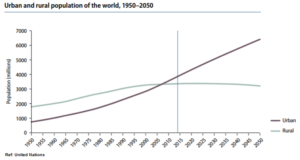 rbanized regions include Northern America (82 per cent living in urban areas in
2014), Latin America and the Caribbean (80 per cent), and Europe (73 per ce
nt). In contrast, Africa and Asia remain mostly rural, with 40 and 48 per cent of their respective populations living in urban areas. Therefore, the risk is real, it is only reasonable to try to find ways to implement long-term solutions.
In this sense, the introduction of green areas has been a way
to increase quality of life for centuries. The popular usage of trees like the platanus (image) was used to reduce temperature, as well as wa
ter fountains that humidified the air and reduced stress for strollers. In the last years, measures like the introduction of bicycles and electric public transportation reduced car usage, and garbage separation increased the efficiency of waste management.
But is it enough? Cities already face considerable problems because of poor urban planning or short-term measures. To mention some of them: The excessive use of concrete reduces floor absorption and increases flood risks, while at the same time high consumption of drinking water, affects the lowering of groundwater levels or increases the stress in the delivery system. Contamination caused by industrial activity as well as the unattended disposal of waste, provoke water pollution. When not taken into account, this problems end up exploding in the form of social and environmental problems such as differences between population groups, stress loads, accidents, disease, crime.
Considering the speed of urban growth and the technological evolution of materials (that allows new ways of building and designing), it is not that crazy to think that we can find schemes that adapt to nature´s ways, instead of confronting and trying to control them.
“Permaculture” practices look for
ecologically responsible agriculture,
landscaping and habitat design techniques.
The term was created in the 1970s by two Australians.
Urban permaculture incorporates a harmonic interaction between artificial materials and nature’s ecosystems. It translates these examples into best practices for sustainable city planning and design. It looks to create more sustainable urban communities and encourages city governments and residents to nurture and rehabilitate public and private spaces, with techniques that duplicate nature’s harmonious self-regulating systems.
The main principles are to take care of the Earth and people, limitate resource consumption and distribute surpluses in an equitable way. Correspondingly, it implies the conservation of resources and implementing strategies to rehabilitate ecosystems in urban areas through intentional design.
The “Water Park”, Benthemplein, Rotterdam, inaugurated to combine water storage with the improvement of public spaces.
It requires working with nature in a respectful way to create an environment that supports humans, animals and plants. But to achieve this, new policies and reglamentations should be enforced to help prevent further degradation of air, water, and land. Their best practices use the multi-use of land as the cornerstone of urban planning. These design techniques create smart cities that integrate activities such as work, shopping and recreation with housing.
Moreover, it incorporates ecological construction techniques for residential, commercial and public construction, including the use of recycled materials, carbon-friendly heating and cooling systems, and water systems that collect rainwater or reduce the use of fresh water. Strategies such as green roofs increase the amount of vegetation available to help clean urban air. They also reduce energy use by providing natural insulation in both hot and cold climates.

In 2015, France passed a law that said that all new buildings constructed in commercial areas should be partially covered by either solar panels or green roofs.
If at this point of the post you think this is too much, that this ideas are not applicable to urban spaces, then you should probably stop reading, because there is even more crazy coming. The cultivation of native plants is an important urban permaculture practice that helps balance the use of natural resources. It also encourages the return of wildlife foraging in local vegetation, and decreases the need for pesticides to control non-native plants and weeds. Moreover, this practices support the rehabilitation of urban stormwater runoffs.

Insect hotel to balance ecosystem often eliminates the need for toxic pesticides. Urban home, Berlin 2016.
Edible landscaping and community gardens are permaculture strategies that reduce food security in urban areas. They also provide opportunities to enrich and replenish urban land by composting post-harvest residues rather than relying on chemical fertilizers. Planting fruit trees and nuts also improves biodiversity. The increased availability of locally produced food also reduces the energy used for transportation to deliver food from distant places.
Wild animals, the refugees of the future?
Today urban areas — ranging from Times Square to a small town in India — cover perhaps 3 to 5% of global land. Karen Seto, a professor of the urban environment at Yale and the lead author of the PNAS paper, points out that between now and 2030, urban areas will expand by more than 463,000 sq. mi. (1.2 million sq. km). By then, a little less than 10% of the planet’s land cover could be urban. “There’s going to be a huge impact on biodiversity hotspots and on carbon emissions in those urban areas,” says Seto.
The PNAS researchers estimate that urban expansion will encroach on or displace habitats for 139 amphibian species, 41 mammalian species and 25 bird species that are either critically endangered or endangered. In addition, as we clear land for those new cities — especially in the densely forested tropics — carbon will be released into the atmosphere as well. “In developing countries, there is a lot of pristine land and hotspots that could be threatened by the process of urbanization,” says Seto. (Extract from science.time interview to Karen Seto).
In these circumstances we need to start asking ourselves about the limits we should put to urban expansion. We are used to hear about companies that contaminate and poor people’s emplacements who need to be “educated” to be friendlier towards the environment. However, we seldom hear about the emplacement of houses or hotels in protected areas, where rules are bent by the weight of money. This kind of initiatives must be taken into account and stopped, for the damage in the long-term is huge.
Conclusion:
Governments must implement policies to ensure that the benefits of urban growth are shared equitably and sustainably. However, governments rarely act if they are not “pushed” by their voters. Therefore, individuals need to start having a more active role in the future picture of the places where they live. In this sense, Habitat III Conference had many proactive initiatives to share spaces where people from all over the world could share their vision about their own reality.
The first city in human history was the Sumerian city of Uruk, sometime between 4500 and 3200 B.C. Scientists do not seem to agree fully on the reasons why people decided to build it. But they agree that over-population and the depletion of resources, were the reasons why this city was abandoned (in fact the city was emplaced where today stands the Desert of Irak, and it is the first registered human-provoked desertification process). We had five thousand years to learn our lesson, now is the time to put it into practice.
References:
http://beta.sedac.ciesin.columbia.edu/data/collection/gpw-v3
https://esa.un.org/unpd/wup/Publications/Files/WUP2014-Highlights.pdf
habitat3.org
Enviar comentario /
27 Jan 2017
por
sestevez
IMSD /
Save Hackney Wick
Urban Planning: Save Hackney Wick
Many things have changed since the London 2012 Summer Olympics; the world was struck by a global financial crisis, the UK voted to leave the European Union, COP21 in Paris made promising headway to tackle the world’s Climate change but was quickly trailed by Donald Trump’s election as President of the United States… Despite the myriad of changes that have occurred over the past five years there remains a corner of East London working hard to hold onto its traditions.
Hackney Wick, moored alongside the Lee Navigation River, is alive with creativity, music and history. Juxtaposed with the renovated Olympic Park are old factories lining the canal. These factories and warehouses hold an important message; there is a way to preserve affordable rents in a market of seemingly exponential growth.
The wake of summer 2012 brought many economic benefits to London, possibly most notably to the construction industry with powerful businesses choosing to invest in the region to build properties with a river view. However, in order to make way for the 17 days of glory1, casualties were also incurred. 450 tenants2 were forced out of their low rent accommodation Clays Lane housing estate East London and displaced into more expensive, often unaffordable, places elsewhere. In sighting the impression that the benefits from the Olympic games are to a rich portion of the community, and not to offer additional welfares to the local people.
The Local Plan is a series of policies set up to utilise the renovations to London in the lead up to, and since summer 2012, whilst at the same time securing heritage buildings and conservation areas, all identified within the policy. Moreover, to regularly review the way to manage the effects and impacts of new developments in the East of London3. With the aspiration to promote regeneration for socio-economic and environmental factors in the surrounding area, the methods for providing low-cost workspaces are detailed in the policy as follows:
Providing low-cost and managed workspaces: Existing managed and low-cost workspace shall be retained where viable and where it complements wider plans for the area. New managed workspace and/or low-cost workspace will be encouraged.4
Furthermore, there are a series of characteristics to be met in order for the Local Plan to be activated to conserve affordable work spaces, the following is a non-exhaustive list must be adhered to; a management scheme is put in place, the spaces will be secured at the low rental value in order to preserve for cultural or creative projects, and it must have associations with a formally registered workspace provider.
Work Spaces
Several factories in Hackney Wick are no longer used for their original industrial purpose, and owing to their large capacity they have been transposed into the above-mentioned workspaces for creative business, artists and musicians. Often these buildings are created by collective yet informal methods to tackle the growing market prices versus what artists can realistically afford to pay. The average rental costs for London in 2016 reached £1509 per month, a staggering £600 increase on prices across the rest of the UK.5 The converted factories undercut this with some spaces costing as little as £300 a month.

The spaces are self-built and self-regulated. Meaning upon moving into the factories the residents are met with a building shell in need of love and attention to transport it to a suitable working environment. Unless the inhabitants want to sleep in the same room that they work they must construct their own bedrooms. These are often made from a few pieces of discarded wood collected from local businesses, pieces of MDF bought from hardware stores, or even a simple curtain to form a minimal visual barrier between work and relaxation. Having been lucky enough to spend many laughter-filled weekends throughout the summer of 2013, drinking ciders as the sun set over the Lee river, I experienced first-hand the community spirt that fills the streets and lines the canals. I believe that the factory settings, such as The Old Peanut Factory, act as a catalyst to build relationships between the neighbours, something confirmed with the offerings of support to construct the makeshift bedrooms by providing tools, supplies and most importantly time.
Nevertheless, a cloud of controversy surrounds these live-in work spaces, owing to some of them not falling under the council tax umbrella. This is a grey area of negotiations which could be abused without the implementation of formal regulations to comprehend who, if any, of the people entering the work spaces are simply trying to obtain cheap living prices, or if they genuinely require full utilisation of the services. Solutions to maintain fair practices within these apartments can once again be traced to the Local Plan initiative which is working to make each unit linked to a workspace provider and reduce self-regulation methods.
Threats
Hackney Wick has a character unique to its occupants, I have not experienced the same feeling elsewhere in London, or across the UK. The Local Plan framework has good intentions to preserve this character however with no formal mechanisms it appears that the conservation is more effective to protect the buildings rather than the inhabitants. The regulation under the Local Plan states that the protected areas cannot be knocked down unless they are being replaced with a suitable alternative, nevertheless the majority of the time the substitute is more expensive and eliminates the current residents from moving into the new structure. Hackney Wick, along with the rest of London, exist in the realm of tenancy agreements with no rent controls to protect against price increases. Despite the live-work spaces having a lower rent than similar sized platforms across London they are not immune to price increases. The landowners are all too aware of the financial benefits on offer if they were to sell their land to construction companies, and with this in mind are able to dramatically increase rent prices every two years. As the workspaces are self-regulated, they have been combatting the increase in costs by sub-letting to additional artists. Adding to the collection of MDF bedrooms and consequently reducing the tangible space available for work. These incremental increases to the buildings charges may soon out-price the creative sector, and in the absence of strong regulations or political commitment there are no devices to prevent industries erasing the conglomerative charm and setting up their office headquarters, or demolishing the existing factories and warehouses to be replaced with state of the art apartments for affluent people.
Outcomes
Throughout my time in Hackney and during my research, there is one thought on my mind: “is it fair to maintain these building’s reduced rents when every day the surrounding areas are becoming increasingly expensive?” My conclusion in short is, yes. Upon reflection it is clear that the scales are unfairly balanced, the prices for suitable work spaces in London are simply too high and should be reduced. It is fundamental to protect people’s right to affordable housing and these converted factories are one method that, for the most part, is succeeding. However, with increasing pressure from developers on landowners, and without a clear method to maintain this in the long term there may be a second wave of displacement concentrated to the creative population. London is considered the world’s creative capital and yet the increasing costs are pricing this demographic out of the market.
Therefore, could ownership be the method to successfully protect these communities from construction industries and companies trying to benefit from the Olympic Games’ impacts? Buying buildings may not a be a sustainable process globally with the complications of raising enough capital to cover the total value, however there are cases in Europe where self-funding has been fruitful. Reported in El Pais during 2013, a co-operative was formed to buy Viktoria Military Barracks building in Hamburg, upon achieving their monetary target it was rented to creative local professionals at affordable, sustainable prices6. An example close to my heart is The Cube Microplex cinema and cultural events venue located in my hometown of Bristol. It is operating under a non-profit co-operative which in 2013 accomplished raising enough funds, with the support of the local community, to purchase the freehold of the building7.

Along the same lines, Save Hackney Wick is a is a non-profit organisation working with local authorities to reduce the impact on the creative community due to the increasing network of developments. Harmonized with the community Right to Bid policy (Localism Act 2011), the community has a right to decide what happens in their neighbourhood9. Vitoria Wharf and Stour space have been categorised as Valuable Public Venues through this policy, it creates a barrier to prevent demolition or modification. The organisation is working to generate money by using the centres as art galleries, music venues, cafés and studios; putting the money back into the community through the local borough’s Action Plan. This can be summarised with the description,“Stour Space was once a disused, unsafe building, and through the intuition and motivation of the local community it blossomed into a multi-functional venue8,” The success of these two creative spaces and the money generated by the non-profit organisation will be invested to support the local council with their budget cuts by community lead and community engagement methods. A positive feedback loop – the community supports the complex and in turn the complex support the community.
Conclusion
Therefore, in conclusion, many things have changed since 2012, but one of the most important things to remember is the subsequent message; the main changes made to neighbourhood are implemented through policies and regulations, but where bureaucracy does not allow for community conservation or fair living standards, Hackney Wick has proven that local people hold a great deal of power and are a vital mechanism to implement and maintain a social, economic and environmental balance.
Save Hackney Wick.
References
Communications
Marrero, 1., 20017. [Telephone conversation on Hackney Wick Affordable Workspaces] (personal communication, 18 January)
Websites
1 Olympics (2012), http://guardianlv.com/2012/07/17-days-of-glory-the-2012-olympics/, accessed 25/01/2017
2 Displacement (2008), https://www.theguardian.com/uk/2008/jun/02/olympics2012, accessed 25/01/2017
3 Local Plan, http://www.queenelizabetholympicpark.co.uk/-/media/lldc/local-plan/adoption-july-2015/lldc_localplan_2015_interactive100dpi-(4).ashx?la=en, page 5
4Local Plan, http://www.queenelizabetholympicpark.co.uk/-/media/lldc/local-plan/adoption-july-2015/lldc_localplan_2015_interactive100dpi-(4).ashx?la=en, page 34
5 Rent Prices, https://homelet.co.uk/homelet-rental-index/london, accessed 25/01/2017
6Hamburg Affordable housing (2016), http://elviajero.elpais.com/elviajero/2016/12/15/actualidad/1481814894_704970.html, accessed 25/01/2017
7The Cube (2016), http://www.cubecinema.com/about/, accessed 25/01/2017
8Stour Space (2016), https://savehackneywick.org/stour-space-and-counter-cafe accessed 25/01/2017
9Localism Policy (2011), https://www.gov.uk/government/publications/2010-to-2015-government-policy-localism/2010-to-2015-government-policy-localism#appendix-1-community-right-to-build, accessed 25/01/2017
Images
Image 1: Hackney Canal (2013), http://fadmagazine.com/2013/07/29/gosee-the-floating-cinema-the-extra-ordinary-sailing-to-a-dock-near-you-throughout-london-this-summer/ accessed 24/01/2017
Image 2: The Cube Microplex (2015), http://www.lilydoughball.com/2015/01/13/bristols-best-bits-cube-microplex/, accessed 27/01/2017
Enviar comentario /
27 Jan 2017
por
jyoung
IMSD /
Pontevedra: a city model focus on people
Pontevedra is a city with history, its beginnings go back to the ancient era. It is said that the city was founded by Teucro, one of the heroes of the Trojan War. This allow us to know how important Pontevedra is according to history and the importance that already have in the actual world and the importance that is going to have in the future.
Pontevedra’s urbanism is in some way conditioned by the physical conditions of their territory, so the original urban planning of the city is adapted to this situation, being the “Rias Baixas” an important part of this, the city is planed around one of them.
These headlines allow us to know a bit more about this ancient city with a pioneer urbanism model and how as a millennial city it reinvents itself with citizens as protagonists and urbanism and technology as allies.

Pontevedra have an experience of 14 years where they have been trying to create a deep improvement of the urban environment and a high urban quality in all its facets. Thus they focus in the following objectives.
-Drastically reduce air, noise and water pollution
-Achieve an inclusive city in which social class, physical or disability barriers, by age, sex or any other diversity are mitigated or eliminated.
-Eliminate the dangers of traffic and enhancing non-motorized mobility, reversing priorities and placing foot-travel as a central element of urban mobility.
-Convert urban public spaces, the city, into a center of socialization a city of integrated plural uses
-Promote the autonomy of children and their integration into urban life
This project shows that more than two-thirds of the trips are made by foot or on bicycles, physical barriers for wheelchairs and children’s cars have disappeared, the whole city has a top speed of 30 km / h;
Pontevedra has become in recent years in a model for many cities that look at how in just 15 years more than 70% of urban displacements are done by foot or by bicycle.
C02 emissions in the urban centre have been reduced by 88%, besides liquid wastes that were returned to nature without purification have been eliminated by 70%.
And the danger of traffic has been drastically reduced, and there are no deaths or serious injuries. In addition, public spaces and green areas, as well as pedestrian and bicycle paths adding the recovery and rehabilitation of the Historic Center and other degraded urban areas have been increased
As a result of this different performances the city of Pontevedra received in 2015 the UN Habitat Award in Dubai, which recognizes the best practices in cities throughout the world that seek to improve people’s lives.
In this sense, the work of Pontevedra has been recognized in terms of innovation, urban quality and social inclusion within its model city. Its urban planning model focus in 7 main points:
1. In 1999 traffic was closed in the city centre and since then it has managed to reduce vehicle pollution in the urban area by 66%,
2. Besides it has reduced the maximum speed to 30 km / h to achieve a calm and safe circulation
3. In 14 years 40 km of footpaths and cycling paths have been created near the rivers.
4. Eradication of wastewater discharges in rivers
5. The recognition of Its urban model as a transferable model, since it can be perfectly executed in other municipalities without no obstacle.
6. It has been constituted as an inclusive social city that allows people with some physical disability to move smoothly throughout the city
7. Pontevedra has been considered a healthy city by the increase of green areas, places to practice sport, as well as its fluvial beach.
As said Daniel Macenlle said in the conference in Dubai:
| “Cities can be transformed into friendly, ecological, sustainable, safe, comfortable, and inclusive places in a relatively short period of time” |
Pontevedra is the perfect example about how is possible to create a “city model” focusing on people and how to make the city more sustainable without forget that the people who live in the city is as important as this idea.
Words from the the major of Pontevedra, Miguel Anxo Fernández Lores:
| “Here there is a deep philosophy that is to know what is important in cities and for us this are the citizens, it is to build a city for people; There are others that are made for cars, for noise but we believe that public space has to be the continuity of your home and from there you start to make decisions” |
At the beginning this ideas was not the most popular one, due to the fact that citizens especially in the case of local shops were worried for their commerce. They thought that the prohibition of cars in the city centre would have a negative impactive in their sales.
Nevertheless this is far from reality, the local commerce are doing better and even some of them are asking for more pedestrian zones. People have learnt and see how their quality of life have improved with this revolutionary urban planning model, even if at the beginning they were not enthusiastic about this Municipal General Town Planning Plan. Nowadays more and more people are getting engaged with this project that helps to improve their quality of life.
Besides Pontevedra was awarded in 2013 with the INTERMODES price for creating the first European pedestrian map: “El Metrominuto”, that shows the result of a policy of years prioritizing pedestrian mobility.
With this project Pontevedra face its self as a pioneer city in urban planning focus in pedestrian mobility
Words of Pontevedra’s Mayor Miguel Anxo Fernández Lores
| “In Pontevedra a revolution was made, not only for reserving a special place for pedestrians in mobility plans, but also because it integrates the pedestrian network into the city’s transport plans” |

Citizens have several public parkings outside the city centre where they can leave their cars and
accede walking to the city what is more comfortable, but even with that people who live in the outskirts of Pontevedra or even in near villages are still struggling with this issue. They say that these parking are not enough and they say that even some of them are not the safest places to leave your car.
Thus in the town hall of Pontevedra they are trying to adapt and modulate its strategy to be able to extend its model to the edge and the periphery and to achieve a balanced territorial development through the next initiative and projects:
-Extension and adaptation of the people-centered urban transformation model: extending it to the peripheral neighbourhoods and the peripheral crown of medium density that surrounds the compact city, they try to create a city better connected with its peri-urban environment, to achieve more friendly, comfortable, safe and accessible urban spaces and a high urban quality that meet the standards reached in the most central grid of the city.
-Compromise with a natural and cultural heritage and commitment with climate change
-To achieve an economic and social cohesion
And as we explain before the town hall is taking into account the “DUSI strategy” based in Model Urban Pontevedra that has as main challenge to deepen the model of urban transformation of Pontevedra focused on people, continuing, reinforcing and adapting its model not only in the urban centre but also in urban spaces of the edge and the urban peripheral crown that surrounds. Pontevedra is still really involved in sustainable urban planning and wants to become in a city model.
From a urbanism and planning point of view creating a urban planning like this it is not easy at all, especially if we consider how in the actual world and particularly in Spain people centers their displacements in the use of car. This is what makes Pontevedra’s urban planning so special and innovative, being a city focus on the safety of their citizens and in achieve a Urban sustainable development strategy.
As a special connotation Pontevedra is the perfect example about how the traditional urban planning is leading its place to the new “urban strategic management” explained by François Ascher. This new method comes up as a response to the uncertainty of the current situation; this method tries to take positive advantage of all kinds of events and developments related to strategic objectives and revolutionizes the old chronology used by traditional urban planning.
As a final conclusion Pontevedra is the perfect example about how cities can change and about how urban planning can focus their planning on people, at the end we are going to be the ones living there.
Pontevedra is leading the new urban planning of the future, why don’t we take their example and try to make our cities more sustainable and oriented to citizens?

Lara Sastre-Estévez de la Torre
SOURCES
abc. (2017). Pontevedra: un modelo internacional de ciudad con «movilidad responsable». [online] Available at: http://www.abc.es/motor/reportajes/abci-pontevedra-modelo-internacional-ciudad-movilidad-responsable-201512032039_noticia.html [Accessed 26 Jan. 2017].
Ascher, F. (2004). Los nuevos principios del urbanismo. 1st ed. Alianza Editorial.
Anon, (2014). Pontevedra: un modelo de ciudad centrado en las personas. [online] Available at: https://intensificacioniga.files.wordpress.com/2014/11/a_02-pontevedra.pdf [Accessed 26 Jan. 2017].
Estrategia de Desarrollo Urbano Sostenible e integrado de Pontevedra. (2016). 1st ed. [ebook] Pontevedra. Available at: http://www.pontevedra.gal/web2015/wp-content/uploads/2016/01/URBAN_Mais-Modelo-Pontevedra.pdf [Accessed 26 Jan. 2017].
Pontevedra, mejor a pie. (2012). 1st ed. [ebook] Pontevedra. Available at: http://www.pontevedra.eu/pub/documentos/20140128070101_mejor_a_pie.pdf [Accessed 26 Jan. 2017].
Pontevedra Viva. (2017). Dubái ‘corona’ el modelo urbano de Pontevedra con el premio ONU-Hábitat – Pontevedra Viva. [online] Available at: http://pontevedraviva.com/xeral/18165/dubai-coroa-modelo-urbano-pontevedra-premio-onu-habitat/?lang=es [Accessed 26 Jan. 2017].
Twenergy.com. (2017). Pontevedra recibe el premio ONU Habitat por su modelo urbano peatonal – Twenergy. [online] Available at: https://twenergy.com/a/pontevedra-recibe-el-premio-onu-habitat-por-su-modelo-urbano-peatonal-1639 [Accessed 27 Jan. 2017].
1 comentario /
27 Jan 2017
por
lsastreestevez
IMSD /
How Chicago Will Help Achieve the Paris Agreement
 Cities are responsible for two-thirds of the world’s greenhouse gas emissions and 70 percent of energy consumption1. When countries met at COP22 to discuss how to implement the Paris Agreement, Ede Ijjasz-Vasquez of the World Bank vocalized the importance of partnerships with cities when he said “In Marrakech, the focus was on how to implement the Paris Agreement, and bring national and local governments together to tackle what is likely the most enormous challenge in our lifetime.” 1 Based on the United Nations 2016 Emissions Gap report, we know that we are not currently on track to hit the Paris Agreement goal of limiting global warming to 1.5°C above pre-industrial levels2, so we need more action to reduce greenhouse gas emissions, and at a faster rate. Cities could be the key to close this gap. Steve Hammer for example, climate specialist for the World Bank, stated “Cities are the most important factor in the climate equation, and need additional tools and support to put them on a sustainable, resilient, low-carbon path.” 1
Having lived in Chicago for the past 11 years, I am particularly interested in what my hometown is doing to help achieve the goals of the Paris Agreement. Just days into the Trump Presidency, Trump made it clear his administration would dismantle climate policy in order to allow the United States to increase the use of fossil fuels and revitalize the coal industry3, so it has never been more important for cities and local governments to do everything in their power to stay on that low-carbon path mentioned by Steve Hammer. For Chicago, steps towards a sustainable and low-carbon city started with the Chicago Climate Action Plan in 2008, which put forth a major goal to cut 80% of greenhouse gas emissions by 20504.

Source: City of Chicago (2008) Chicago Climate Action Plan
Following the Chicago Climate Action Plan, the city introduced the Sustainable Chicago 2015 plan in 2012 that provided a very clear action plan in order to hit sustainability goals. In 2015, the city released a report highlighting progress of Sustainable Chicago, and next steps to achieve any goals not met in the plan. However, the goals in the Paris Agreement are deservedly aggressive, so there is little room for failure in achieving everything that was set forth in Sustainable Chicago 2015 and the Chicago Climate Action Plan. In Chicago, 70% of greenhouse gas emissions are from buildings and their energy use, and 21% of emissions are due to transportation4. Therefore, I analyzed what has been achieved in Sustainable Chicago 2015 for buildings and transportation, as well as action plans for goals that are still in progress, all while drawing from my experience of living and studying in Madrid to determine if what other cities are doing can inspire future action plans for Chicago.
Buildings and Energy Use
Chicago has seen some great mitigation and adaptation successes when it comes to buildings and energy use. One major accomplishment when it comes to energy, that has benefits such as improving air quality and decreasing greenhouse gas emissions, was closing the 2 coal plants (Fisk and Crawford) that were located in heavy populated areas of the city. This decision helps improve the health of the city’s inhabitants, while putting Chicago on a more sustainable path for clean energy.
Other programs have come to fruition through a partnership with C40, a network of the world’s largest cities committed to addressing climate change, and while these programs have shown progress, it imperative to keep these initiatives rolling:
- Retrofit Chicago, which strives to achieve increased energy efficiency of 20% 7, through commercial, residential and municipal building retrofit programs. As of 2014, 48 commercial buildings have experienced $2.5 million in savings and 7% reduction in energy use, residential buildings have experienced $5.9 million in savings and 15% reduction in energy use, and 60 municipal buildings have experienced $1.4 million in savings and 18% reduction in energy use7. Increased energy efficiency is key in reducing greenhouse gas emissions, and this program must be rolled out to as many buildings as possible so the city can continue to see cost savings and energy reduction.
- Green Office Challenge, which is an innovative platform and challenge designed to measure energy use and other sustainable activities, incentivize participants to reduce use of resources, all while incorporating some friendly competition. The 2014-2015 challenge concluded with participation of 170 offices that reduced energy (690,000 kWh) water (705,000 gallons) and waste (71 tons)8. Employees who participated also took home valuable lessons and practices in sustainability, which helps create awareness of sustainability and its consumer benefits. However, this challenge could be seen as a small pilot, and I have struggled to find any information on the program post 2015. To continue to make an impact, the program needs to continue to run, and this platform could be rolled out on a larger scale to not just include offices, but larger buildings and businesses such as universities or hotels.
- Chicago Energy Benchmarking is policy designed to provide transparency through energy reporting, so building owners and tenants can make more informed decisions when it comes to energy consumption. More informed decisions ultimately lead to large energy savings and reduced greenhouse gas emissions. Currently, 2,600 properties participate in this program9, but this policy needs to encompass the entire city. In the Sustainable Chicago 2012- 2015 Highlights report, the city announced plans of rolling this out to all buildings over 50,000 square feet6.
Chicago is also working with ComEd, an electric utility company, to install SmartGrids across the entire city by the end of 2017. SmartGrid technology will allow consumers to understand their use of energy during peak hours, which are the most expensive hours to use energy. If consumers can reduce their use during peak hours, they can save on energy costs, while also reducing the amount of greenhouse gas emissions. This is a great program, but I believe there is little knowledge about this program and how to use it, and a larger communication strategy is needed to inform inhabitants about the benefits. My neighborhood has the new SmartGrid technology installed, and my roommates and I were not aware and have not been taking advantage of this program.
One area where Chicago is not on track to meet their goals is the goal of adopting more renewable energy as a power source. Sustainable Chicago stated the city would “work with ComEd, the State of Illinois, and other partners to assist in achieving the Illinois Renewable Portfolio Standard goals of 9% of electricity coming from renewable energy by 2015 and 25% by 2026”5, a goal which even the city says has seen only moderate progress. A 2016 report by the Illinois Department of Commerce and Economic Opportunity shows that Illinois did not meet their goal in 2015 to require 10% of electricity sales to come from renewables10. This means Illinois is also not on track to meet the goal of 25% of electricity sales to come from renewables by 2026.
An article published by the Illinois Clean Jobs Coalition says Illinois is struggling to meet these goals due to conflicting energy laws and policy. One law that is in the process of being passed prioritizes nuclear energy, which can directly compete with the law that is trying to be passed that prioritizes renewable energy standards. Stronger collaboration between all energy companies and policy makers is needed to form policy that works for all parties, and puts Illinois and Chicago on the path towards increased renewable energy sources and lower carbon emissions.
Transportation
One goal that was met in the transportation sector was the goal to “make Chicago the most bike and pedestrian friendly city in the country”5. Since 2012, Chicago became the second most bike friendly city in the US through the introduction of the Divvy bike sharing program which consists of over 4,700 bikes at solar powered stations, as well as the creation of 100 miles of improved bike lanes. The city continues to invest in bicycle infrastructure by adding miles of bike lanes and more bikes to the Divvy program. More opportunities for bikers take cars off the road, resulting in reduced greenhouse gas emissions.
A goal that continues to see progress is the goal to “strengthen the infrastructure to advance vehicle efficiency” 5. Most of this goal was focused on the transition to vehicles with cleaner fuels in partnership with the Chicago Area Clean Cities Coalition. Through programs such as Drive Clean Taxi and Clean Fuels Across Chicago, taxi fleets and city facility fleets are incentivized to switch to cleaner fuels or electric/hybrid vehicles. The Chicago Area Clean Cities Coalition website also provides information on the location of electric charging stations, and the Drive Electric Chicago portion of the city’s website gives you information on how to install charging stations at home.
However, I believe there is little awareness of the ease and benefits of driving electric or hybrid vehicles in Chicago. One business which has seen success in Madrid, and could help create awareness of electric vehicles while at the same time significantly reduce carbon emissions, is Car2Go. Madrid’s Car2Go program is one of three Car2Go fleets that are completely fitted with electric vehicles. Car2Go is active in 25 cities overall, but if Chicago adopted this program, an electric only fleet would be necessary to reduce environmental impacts, and give an alternative to the current car sharing programs that don’t provide as many electric or hybrid options.
Finally, a goal that I believe needs to be more aggressive is the goal to “increase average daily transit ridership” 5. Increases in daily ridership would reduce carbon emissions and reduce traffic problems, as less cars are driven, but also provide economic benefits for the city and businesses surrounding public transit stops. In the Sustainable Chicago 2012 – 2015 Highlights, the city says that they are experiencing advanced progress in increasing daily ridership. However, I believe that is only because the goal is not designed to accomplish major public transit changes that will increase ridership for many of the areas on the south or west sides that are somewhat isolated from fast, public transportation options.
After living in Madrid, which has a population of 3.2 million vs. Chicago’s 2.7, I have been exposed to a public transit system that makes getting anywhere in this city very fast and easy. This is mostly due to the large investment in the Metro system (it helps that the Metro is a private-public partnership), the amount of connections from one line to another, in addition to the frequency at which the trains run. A quick comparison of the two train maps below show how many more connections exist in Madrid (accomplished in particular with the “circular” line) vs. Chicago, whereas Chicago’s system is centered around the downtown “loop”, so going from one area to another outside of downtown becomes difficult and time consuming. Traveling north – south on Chicago’s west side is particularly difficult.

The Ashland and Western express buses in Chicago are meant to help with this much needed north -south connection, however a Bus Rapid Transit (BRT) system or additional “L” line would be much more efficient. Chicago has tried to introduce a BRT on Ashland and Western, but there was community pushback due to the poor design of what was proposed, so this BRT project has been stuck in planning phases. To Chicago’s credit, they did launch a BRT in the Loop called Loop Link – it is a step in the right direction, but only focuses on the downtown area which already has other public transportation options with the “L”. Chicago could look to Brazil’s Curitiba BRT system for more inspiration. Curitiba’s BRT features priority and dedicated lanes for buses, but still allows room for multiple lanes of local traffic (something the Ashland and Western BRT plans lacked), as well as boarding stations that collect fare prior to boarding the bus, which allows for faster and higher capacity boarding. As to not disrupt local traffic at all, another elevated train line would be the best option, but it would be expensive; Curitiba introduced their BRT at a much lower cost that a light rail or train.
Conclusion
After studying Sustainable Chicago 2015 and its progress, as well as various news updates and articles, it is clear that Chicago has put concrete goals and actions in place to stay on a sustainable and low-carbon path, and in most areas, the city is progressing and on track to meet goals. However, even when goals are met or new innovative programs are created, many city inhabitants are not aware of the achievements, so I believe the city could benefit from more awareness campaigns on the progress and benefits of sustainable solutions. I also believe the city’s transportation goals are not strong enough, and to really see a transformation in the ridership of the public transportation system, neglected areas of the city need better connections to the “L” train system. Other cities have implemented solutions that Chicago can look to for inspiration when goals are not met, so I am happy to know that Chicago is part of the C40 network and 100 resilient cities, as this demonstrates global collaboration.
Sources
- World Bank Group (November 2016) “COP 22: Three New Ways to Help Cities Reach Their Climate Goals” Retrieved January 9, 2017 http://www.worldbank.org/en/news/feature/2016/11/28/cop-22-three-new-ways-to-help-cities-reach-their-climate-goals
- United Nations (November 2016) The Emissions Gap Report 2016 United Nations Environment Programme (UNEP) Retrieved January 11, 2017 http://web.unep.org/emissionsgap/
- White House (January 2017) “An America First Energy Plan” Retrieved January 24, 2017 https://www.whitehouse.gov/america-first-energy
- City of Chicago (2008) Chicago Climate Action Plan Retrieved January 9, 2017 http://www.chicagoclimateaction.org/filebin/pdf/finalreport/CCAPREPORTFINALv2.pdf
- City of Chicago (2012) Sustainable Chicago 2015 Retrieved January 9, 2016 https://www.cityofchicago.org/content/dam/city/progs/env/SustainableChicago2015.pdf
- City of Chicago (2015) Sustainable Chicago 2015 Action Agenda 2012-2015 Highlights and Look Ahead Retrieved January 9, 2017 https://www.cityofchicago.org/content/dam/city/progs/env/Sustainable_Chicago_2012-2015_Highlights.pdf
- City of Chicago (2014) Retrofit Chicago Summary August 2014 Retrieved January 21, 2017 https://www.cityofchicago.org/content/dam/city/progs/env/RetrofitChicagoSummaryAugust2014.pdf
- Delta Institute (June 215) “Tally Is In: Chicago Green Office Challenge Announces Winners” Retrieved January 21, 2017 http://delta-institute.org/2015/06/tally-is-in-chicago-green-office-challenge-announces-winners/
- City of Chicago (2016) City Of Chicago Energy Benchmarking Report 2016 Retrieved January 21, 2017 https://www.cityofchicago.org/content/dam/city/progs/env/EnergyBenchmark/2016_Chicago_Energy_Benchmarking_At-A-Glance.pdf
- Illinois Department of Commerce (2016) State of Illinois Goals Status Report for Energy Efficiency and Renewable Energy Retrieved January 26, 2017 http://www.eenews.net/assets/2016/03/28/document_ew_03.pdf
- Tomich, Jeffery (April 2016) “Ill. Clean Energy Standards Slipping Away As Policy Stalemates Drag On, Report Says” Illinois Clean Jobs Coalition, Retrieved January 26, 2017 http://ilcleanjobs.org/4516-ill-clean-energy-standards-slipping-away-as-policy-stalemates-drag-on-report-says/
- ComEd (2017) Smart Grid and Smart Meter Retrieved January 26, 2017 https://www.comed.com/SmartEnergy/SmartMeterSmartGrid/Pages/Default.aspx
- Chicago Department of Transportation “City of Chicago Launches Drive Clean Taxi to Spur the Adoption of Alternative Fuel Vehicles in Public Passenger Vehicle Fleets” Retrieved January 21, 2017 https://www.cityofchicago.org/content/dam/city/depts/cdot/Sustainable%20Transportation/6-12-15DriveCleanTaxiPR.pdf
- https://www.theguardian.com/cities/2015/may/26/curitiba-brazil-brt-transport-revolution-history-cities-50-buildings
- Reed, Drew (May 2015) “How Curitiba’s BRT stations sparked a transport revolution – a history of cities in 50 buildings, day 43” The Guardian, Retrieved January 21, 2017 http://www.chicagotribune.com/news/ct-transit-study-met-20140914-story.html
- Spielman, Fran (August 2015) “Ashland BRT seems all but dead with return of Ashland, Western express buses” Chicago Sun Times, Retrieved January 21, 2017 http://chicago.suntimes.com/auto-show/ashland-brt-seems-all-but-dead-with-return-of-ashland-western-express-buses/
- Lydersen, Kari (December 2012) “Renewable energy mix in Chicago aggregation plan remains unclear” Midwest Energy News, Retrieved January 21, 2017 http://midwestenergynews.com/2012/12/13/renewable-energy-mix-in-chicago-aggregation-plan-remains-unclear/
- C40 Cities (November 2016) “City Adviser Case Study Series: City of Chicago- Sustainability Strategies and Energy Programs through Direct Support Partnership” Retrieved January 21, 2017 http://www.c40.org/case_studies/city_adviser_chicago
Enviar comentario /
27 Jan 2017
por
Ashley Hodges
IMSD /
Rephrasing the United Nations Energy Goal.
On September 25th in 2015 under the United Nations countries got together and adopted a set of 17 sustainable development goals to transform our world for the better. Each of the 17 goals has a specific target to be reached within 15 years. Goal number 7 states: Ensure access to affordable, reliable, sustainable and modern energy for all. Now in my opinion this goal is very ambitious. The goal set by the United Nations does not only want to ensure energy access for all but takes it a step higher. The goal contains that the share of renewable energy in the global energy mix needs to increase substantially. I do believe th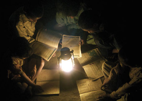 at setting goal number 7 is necessary and important. Setting the goal means that multiple countries have agreed to work together in different types of methods to achieve energy access for all.
Looking at this goal #7 set by the United Nations it seems their goal was not just ambitious but maybe somewhat unrealistic. According to the World Energy Outlook in 2030 there will still be more than 780 million people who will remain without energy access. However there has been major developments and improvements. Even though there are major improvements I believe the goal should be more realistic and should be achievable when set. From everything I have had read and learned I believe there are two most important solutions which are also realistic. Clean cooking stoves should be promoted and marketed in the right way to overcome cultural issues with clean cooking methods and solar lanterns or more advanced solar electricity needs to be promoted more. I think these are the most important solutions to solve health and safety issues. If health and safety issues can be solved, I believe a big step has been made in fighting energy poverty. Therefore, I would like to allow myself to rephrase the United Nations goal #7 to:
SDG#7: Solving global health and safety issues related to a lack of energy access before 2030.
Tim Wierks, IMSD, 2017
Enviar comentario /
09 Jan 2017
por
Tim Wierks
IMSD /
Wider energy access planning to make it universal

Full Earth at night showing city lights of Africa
At Planning Electrification Procedures they both are considered close to good practice. When analysing Procedural efficiency, they got the same RISE score although they present different distance to frontier approach. TANZANIA has more efficient business environment because of their better policies and regulations than KENYA, that receives more support from subsidies and pricing.
Whether one way or another, the combination of grid, mini-grip and off grid energy systems drives universal energy access on the best direction. Based on the needs of the rural community or deprived areas, with a legal and regulatory framework, agreements between the shareholders, support from to government to smaller developers, subsidies programmes and private funds, and also decentralization of energy solution´s providers, any plan can empower wider systems to reach an affordable, relievable, sustainable and universal energy access.
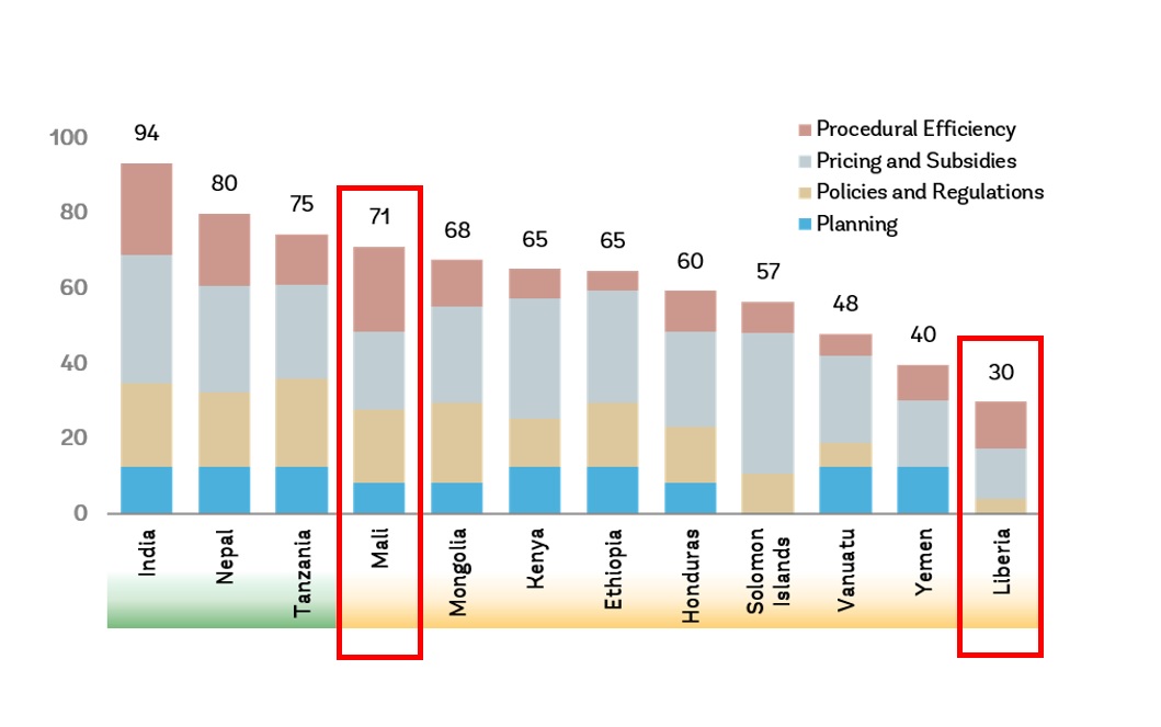

.png)
].gif)
].png)
].png)
].png)
].png)
].png)
